Hiking signs are second to none throughout Switzerland, and making sure you know how to read them correctly is key.
So here the 7 things you need to know how to read on any given yellow sign:
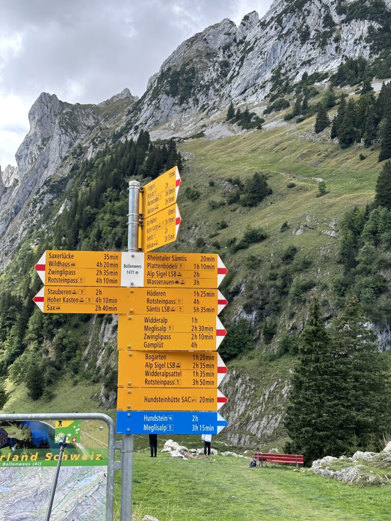
Where you are now and the altitude.
Destinations – where you can go from here (note: when several destinations are listed in the same direction, the closest will be at the top, the furthest at the bottom).
Walking / hiking time (without breaks).
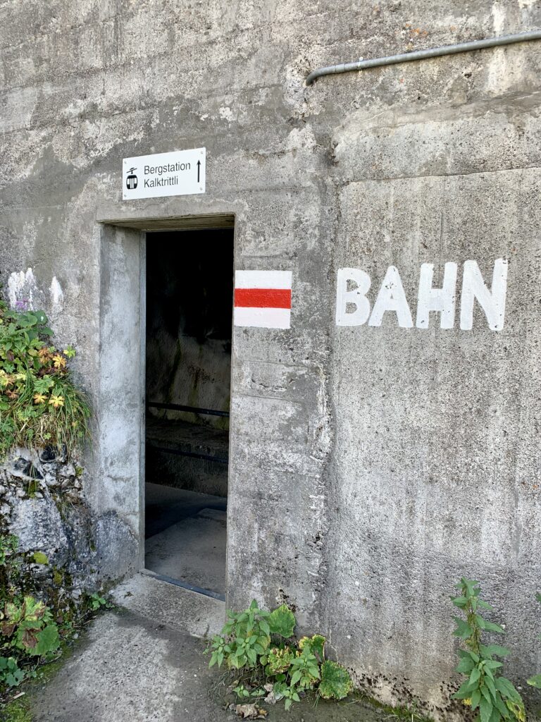
Route type: yellow only = easy walking / hiking trail (easier paths and suited for mostly anyone) white-red-white = mountain hiking trail (proper hiking trails which require proper footwear, knowledge & prep) white-blue-white = alpine hiking trail (for experts only, or get yourself a professional mountain guide)
Dividing line: this tells you that the trail has an intersection along the way.
Symbols: these show you what you can find in that particular direction: a train station, a bus, a restaurant, a viewpoint, a ship…
Itineraries: the green stickers with a number and generally a name, mark specific walking & hiking itineraries (you can find these on the Switzerland Mobility App https://schweizmobil.ch/en/summer
Hiking times: how are they calculated?
Have you ever wondered how they calculate hiking times posted on those signs? On the fit mountain guides or the easy Sunday hikers?
It’s not a stupid question, one that you’ve probably pondered as you pass yet another sign announcing that you’re still 2h 10m from your destination (didn’t the last sign say that??)
I checked and there’s a mathematical formula involved, as well as an interesting bit of history (and some urban legends).
So here’s the formula: On flat paths, the speed per kilometer is calculated as 4.2km/hr, which means that we count a quarter of an hour per kilometer on the flat. Add to this an additional 15 minutes for every 100 meters of ascent or 200 meters of descent, and voila’, that’s the way they come up with those times!
Are you still with me? here’s a little test: let’s say you’re going on a 12 km hike with 400m up and 400m down… how much time will it take?
Leave your answers in the comments below 🙂
But up until the 1980s, they used to send different people to walk the same route and they would average out all the different times to come up with those numbers. However, this method was not very uniform as some cantons always sent the same people while others sent different people – children, adults, the elderly – to complete the routes, which essentially resulted in wildly different “average” times. Rumor has it that certain cantons used their fittest hikers to keep their hiking standards high! (Swiss humor)
A lot of times the alpine hiking signs are totaly blue, that means that the whole way there is “alpine”. Don’t get too adventurous, get a mountain guide instead
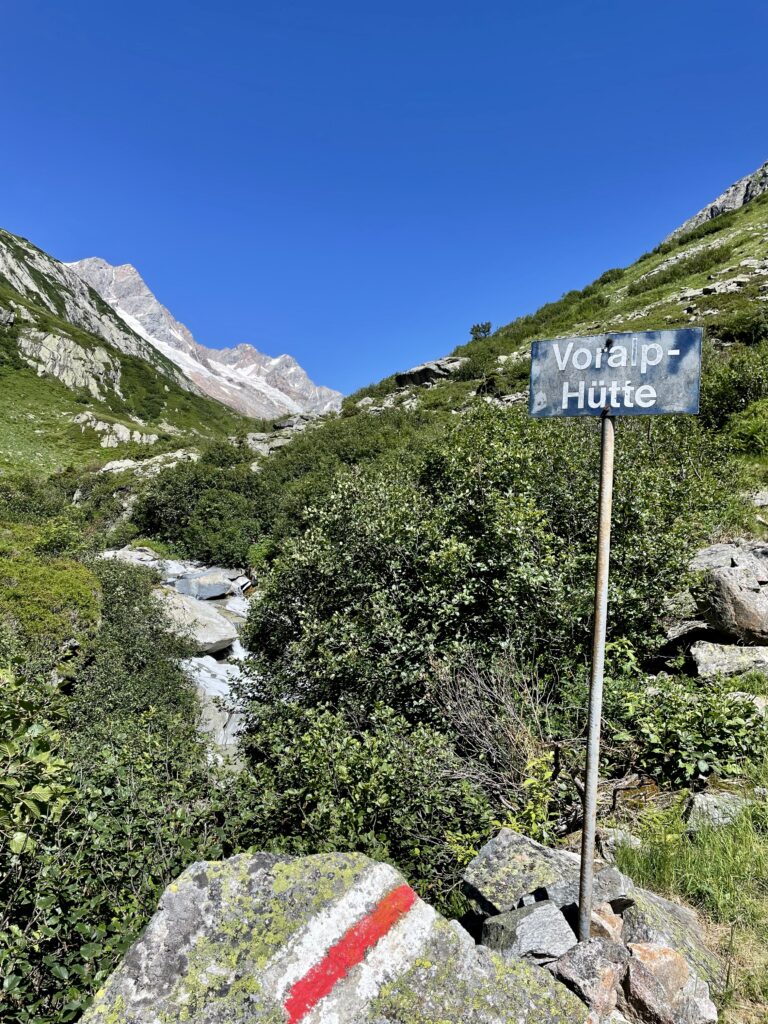
Trail markers along the way…
Now that you know how to read the signs, keep in mind that while you’re hiking on the trails and you’re watching your step, looking around at the views, having a chat with friends… you need to make sure you’re on the lookout for trail markers. What are those? They’re basically painted signs in the colors of the trail you’re on (so white-red-white for mountain trail for ex) and you’ll find them painted on rocks along the trail, sometimes trees, sometimes a wooden stick… their purpose is to mark the path so you don’t suddenly look up and wonder where you are. It’s happened to me a fair amount of times that I had to backtrack and find the way again, or stop other hikers as ask for directions, making me feel like a total beginner 🙂 This is how I learned another essential thing to prepare for any hike: study and bring along a map and/or download your itinerary on an offline map on your phone, so you can always check where you are and where you’re headed to if you should loose your way. As I said before, civilization is always close by, BUT you may end up on a different trail / at a different destination, hut, bus station or you might miss your gondola ride down the mountain, etc etc, which can turn your day into a very loooong one.
Always a good idea to read the maps before you set off so you have a general idea of where you’re headed!! warning: sometimes reading the map is the challenge :)))
First we go up here, then take that trail to the left, right at the intersection and keep going all the way to the Alp… got it???
White-red-white funny trail marker
White-blue-white, you get the idea
Sometimes they look like this !!!
Combo of trail signs and markers
Another interesting one
Another combo
Always happy to hear from you about your adventures on the trails and to see pics of trail markers in the most unlikely places…. post in the comments below and share 🙂